
2. Indus Valley Civilization
Free Ancient India rapid revision notes for UPSC, APPSC and TGPSC. Original notes are presented below with their tables, images and visual aids preserved.
2. Indus Valley Civilization
2.1 Introduction
The Indus Valley Civilization is the earliest urban culture of the Indian subcontinent. It is also called the Harappan Civilization, after Harappa, the first site found. It belongs to the Bronze Age and was contemporary with the civilisations of Mesopotamia and Egypt. It is protohistoric, because its script has not been deciphered.
Discovery
Year / Person |
Contribution |
1826 |
Charles Masson first described the mounds of Harappa |
1921 |
Daya Ram Sahni began excavation at Harappa |
1922 |
R. D. Banerji found Mohenjo-daro |
1924 |
John Marshall, Director General of the ASI, announced the discovery to the world |
1946 |
Mortimer Wheeler excavated Harappa and dated the civilisation by layers |
After 1947 |
Many sites in India were found: Ropar (1953), Lothal (1954, S. R. Rao), Kalibangan, Dholavira (found by J. P. Joshi in 1967-68; excavated by R. S. Bisht) |
Chronology
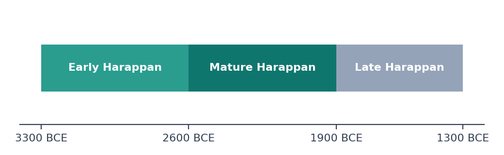
The three phases are Early Harappan (about 3300 to 2600 BCE), Mature Harappan (about 2600 to 1900 BCE) and Late Harappan (about 1900 to 1300 BCE). Older books give different dates: Marshall suggested 3250 to 2750 BCE, and Wheeler 2500 to 1500 BCE.
2.2 Extent and Important Sites
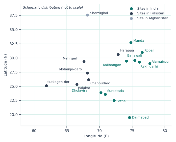
It is the largest of the early river-valley civilisations in area, covering more than a million square kilometres in Pakistan, India and Afghanistan.
Northernmost site: Manda (Jammu). Southernmost: Daimabad (Maharashtra). Westernmost: Sutkagen-dor (Makran coast, Pakistan). Easternmost: Alamgirpur (Uttar Pradesh).
The Indus and the dried Ghaggar-Hakra (often linked with the Sarasvati) were the main river systems.
Site |
River / Place |
Key Findings |
Harappa |
Ravi; Punjab (Pakistan) |
Granaries, workmen's quarters, Cemetery R-37, a red sandstone male torso; later Cemetery H culture |
Mohenjo-daro |
Indus; Sindh (Pakistan) |
Largest site; Great Bath, granary, bronze "Dancing Girl", steatite "Priest-King", Pashupati seal. The name means "mound of the dead" |
Chanhudaro |
Indus; Sindh |
No citadel; bead-making and craft centre; discovered by N. G. Majumdar (1931) |
Kalibangan |
Ghaggar; Rajasthan |
Earliest ploughed field, fire altars, camel bones, black bangles; excavated by B. B. Lal and B. K. Thapar |
Lothal |
Bhogava; Gujarat |
Dockyard, bead factory, rice husk, fire altars, double burial; S. R. Rao |
Dholavira |
Kutch; Gujarat |
Three-part city, stone-built, water reservoirs, a large signboard with ten signs; UNESCO World Heritage Site (2021) |
Rakhigarhi |
Haryana |
Largest Harappan site in India; a DNA study of a skeleton was published in 2019 |
Banawali |
Haryana |
Barley; toy plough; both Harappan and pre-Harappan layers |
Surkotada |
Kutch; Gujarat |
First actual horse bones reported at a Harappan site (J. P. Joshi) |
Ropar |
Sutlej; Punjab |
First Harappan site excavated in independent India (1953, Y. D. Sharma) |
Mehrgarh |
Baloch-istan |
Neolithic precursor, about 7000 BCE; earliest farming in South Asia |
Shortughai |
Afghan-istan |
Harappan trading post for lapis lazuli |
2.3 Town Planning
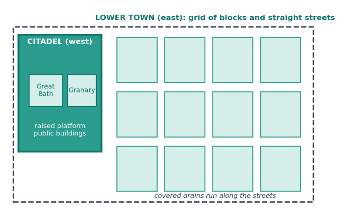
Most cities had a raised citadel (west) for public buildings and a lower town (east) for homes.
Streets ran in a grid, cutting each other at right angles.
Bricks were burnt (baked), in the ratio 4 : 2 : 1 (length : width : thickness).
A well-planned system of covered drains ran along the streets, with house drains joining them.
Houses had bathrooms and wells; many were multi-roomed and built around a courtyard.
Dholavira had three parts (citadel, middle town and lower town) and smart water harvesting; Chanhudaro had no citadel.
No palaces or temples have been clearly identified.
Important structures
Structure |
Details |
Great Bath (Mohenjo-daro) |
A large water tank (about 12 m by 7 m and 2.4 m deep) made watertight with bitumen; probably for ritual bathing |
Granaries |
Large storehouses at Harappa and Mohenjo-daro, near the citadels |
Dockyard (Lothal) |
An artificial brick basin linked to the sea by a channel |
Fire altars |
At Kalibangan and Lothal |
Stadium and reservoirs (Dholavira) |
Water storage cut in rock and large open ground |
2.4 Economy
Agriculture and animals
Crops: wheat, barley, peas, sesame, mustard, dates and melon; cotton was grown (the Greeks called it sindon); rice is found at Lothal and Rangpur; millets at Rangpur and other Gujarat sites.
The plough is shown at Kalibangan and Banawali (toy). Canal irrigation and dams (gabarbands) were used in some regions.
Animals: humped bull, buffalo, sheep, goat, pig, dog, cat and camel; the elephant was known. The horse was not a regular part of life.
Craft, trade and weights
Bronze (copper and tin) and copper were used; iron was not known.
Bead-making (carnelian, steatite, shell) at Chanhudaro and Lothal; shell work at Balakot.
Trade with Mesopotamia (the Indus region was called Meluhha), Dilmun (Bahrain) and Magan (Oman); trade was mainly by barter.
Seals were of steatite, mostly square with an animal (the unicorn is the most common) and a short inscription.
Weights were cubical (chert), in a ratio of 1, 2, 4, 8, 16, 32 and so on, with 16 as a basic unit. An ivory scale from Lothal shows accurate measuring.
Raw materials: copper from Rajasthan (Khetri) and Oman; tin from Afghanistan; lapis lazuli from Badakhshan; carnelian and steatite from Gujarat and Rajasthan.
2.5 Script, Society and Religion
Topic |
Key Points |
Script |
About 400 signs; pictographic; written in boustrophedon style; still undeciphered. Attempts include those of Iravatham Mahadevan and Asko Parpola |
Society |
Mostly urban; signs of social differences in house sizes; a ruling or merchant elite probably managed trade and cities. No clear evidence of kings or armies |
Mother goddess |
Many terracotta female figurines |
Pashupati seal |
A horned figure seated in yogic posture surrounded by animals; John Marshall called it Proto-Shiva |
Nature worship |
Pipal tree, humped bull, snakes; phallus and yoni stones |
Burials |
Usually extended burials with pots and ornaments; double burial at Lothal; Cemetery R-37 at Harappa |
Art |
Bronze Dancing Girl (lost-wax method), steatite Priest-King bust, terracotta toys and animals |
Remember
|
2.6 Decline
Theory |
Explanation |
Aryan invasion (Wheeler) |
Mohenjo-daro skeletons seen as massacre victims; now widely rejected, since the skeletons belong to different times |
Floods (Marshall, Mackay, Raikes) |
Layers of silt at Mohenjo-daro suggest flooding, possibly from tectonic changes |
Climate change and drying of rivers |
The monsoon weakened and the Ghaggar-Hakra dried up; the most accepted explanation today |
Decline of trade |
The fall of trade with Mesopotamia weakened the cities |
Epidemics and ecological stress |
Over-use of land and disease may have added to the pressure |
The cities slowly declined and the civilisation did not end suddenly. Late Harappan cultures continued in villages, such as Cemetery at Harappa, the Jhukar culture in Sindh and the Ochre Coloured Pottery culture in the Ganga-Yamuna region.
Quick Recall
|
Explore structured courses and guidance for your target examination.